The GNNFire Project
Project summary
This project, referred to as "GNNFire" and completed in 2005, investigated use of the Gradient Nearest Neighbor (GNN) method for mapping vegetation and fuels in three contrasting ecoregions in the Western US. The GNN method is described in more detail on our methods page and in our publications.
Prior to the GNNFire project, GNN had been successfully used to generate forest vegetation maps suitable for detailed, stand-level modeling across large multi-ownership provinces in coastal Oregon and central Oregon. However, the method had not been tested in other ecoregions, nor specifically for mapping fuels. Accurate regional maps of vegetation and fuels are needed for assessing fire hazard, planning fuel management, and modeling the behavior and effects of prescribed burns and wildfires. In order for such maps to be useful to land managers, they must accurately predict a large number of vegetation and fuel attributes across heterogeneous, multi-ownership landscapes. We hypothesized that the flexibility of GNN, combined with its capacity for multivariate spatial predictions, would make it particularly useful for developing regional fuels maps.
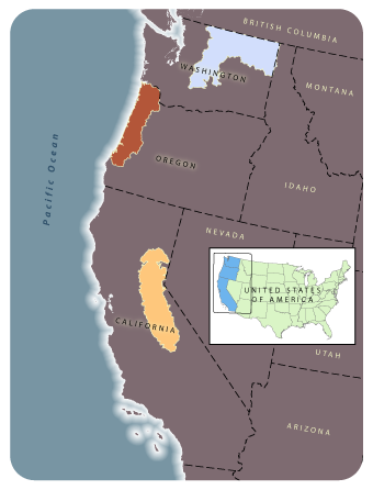
This study examined the utility of GNN for predicting fuel patterns in three prototype landscapes in coastal Oregon, northeastern Washington, and the California Sierra Nevada, which encompass vegetation from dense forests to rangelands in a mosaic of natural and human-dominated environments. Our two primary objectives were: (1) Develop a methodology for using multivariate statistical models and imputation to simultaneously map fuel characteristics, species composition, and forest structure as continuous variables across environmentally heterogeneous, multi-ownership landscapes using inventory plot data, remote sensing imagery, and environmental GIS data layers; and (2) apply this methodology to generate vegetation and fuel maps for pilot landscapes located in three distinctive ecoregion divisions in the western US.
GNNFire Map Products
For the GNNFire project we developed several types of GNN models, which are described on our methods page. The GNNFire maps of the species-size type have now been replaced by more current map products, which can be downloaded from our maps and data page. However, most of the fuels-specific forest attributes are not available for the newer maps, and would need to be developed by the user.
Collaborators and Support
Research collaborators included Mike Wimberly; Jeremy Fried; and the Forest Inventory and Analysis (FIA) Program, Pacific Northwest Research Station (PNW), USDA Forest Service. This project (Project 01-1-4-09) was funded by the Joint Fire Science Program.
Publications, Reports, and Presentations
Loading publications ...